Yao, C., & Fricker, P. (2024). Building Green Decarbonization for Urban Digital Twin – Estimating Carbon Sequestration of Urban Trees by Allometric Equations using Blend Types of Point Cloud. Blucher Design Proceedings, 94–105. https://doi.org/10.5151/sigradi2023-246
For more information please contact: chaowen.yao@aalto.fi
Supervisor: pia.fricker@aalto.fi
2023 – 2024
Building Green Decarbonization for Urban Digital Twin – Estimating Carbon Sequestration of Urban Trees by Allometric Equations using Blend Types of Point Cloud
Abstract
The achievement of climate neutrality is a fundamental goal for cities in the next 30 years. In order to achieve this goal, this research focuses on a novel tree carbon sequestration utilizing point clouds. Using a multi-algorithm workflow, tree information is extracted to calculate carbon storage from airborne and mobile laser scanning data, using Helsinki as a test case. The study employs local maximum and seeded region growing algorithms to detect tree locations and crown extents from aerial point clouds. A Python script is generated using the DBSCAN algorithm to extract tree point clouds and trunk diameters. The established allometric equations are utilized to calculate the carbon sequestration of trees. The results are integrated into the digital platform, filling the gap in urban digital twins’ carbon storage information. This innovative approach will contribute significantly to urban planning and decision-making for sustainable cities in the face of climate challenges.
Aim
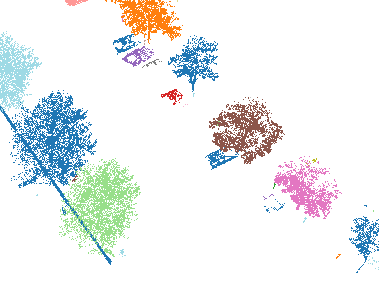
This study aims to measure the CS of trees in urban areas and support decision-making in carbon neutrality and UDTs. CS is calculated based on tree trunk diameter and absolute height, using ALS data for tree height extraction and MLS data for trunk diameter extraction. In the Nordic urban environment, trees are often intertwined with other urban facilities, making it challenging to accurately cluster tree point clouds using conventional methods. To address this issue, a Python script is developed to extract tree point clouds and trunk diameters from MLS data based on point cloud density. Due to the lack of local data, the established allometric equations from existing studies are imported to calculate tree carbon sequestration. Compared to methods employed by other researchers, our approach offers precise tree extraction, and the extracted point cloud information can be integrated into a digital twin platform for more intuitive public display.
Method
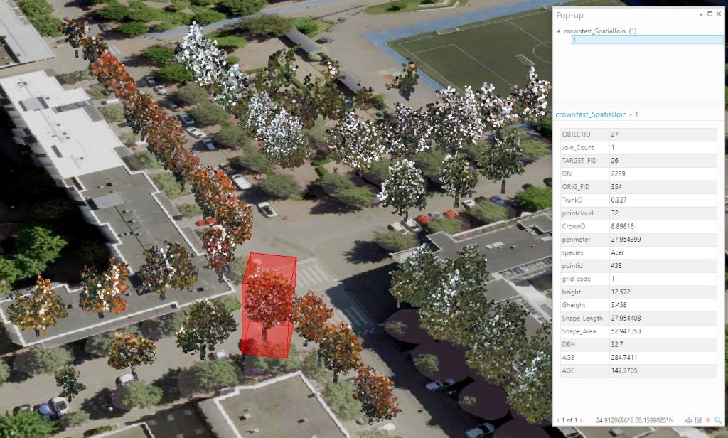
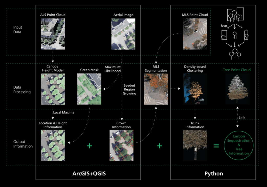
The methodology used blend types of point clouds to estimate the CS of trees. In this study, the ALS dataset’s first output canopy height model (CHM), is used to generate treetops with height information. The orthophoto processed by a random forest classifier is involved in this step to operate misclassified filtration. Based on the detected treetops, the seeded region growing (SRG) algorithm is utilized to delineate tree crowns. The generated tree crown is utilized to crop the MLS point cloud. Then the DBSCAN algorithm clusters trees and the script acquires DBH from 1.3 – 1.4m of tree trunks. Finally, the established allometric equations compute the CS of each tree and link the information with the tree point cloud.
Validation
The extracted trees were compared with the Helsinki tree database in our study area. The database recorded a total of 56 trees, out of which 54 were trees successfully extracted along with the respective point clouds. Regarding morphological information, height information was recorded for all extracted trees, while DBH information was obtained for 49 trees. 4 trees failed to get separated from urban objects by the clustering algorithm, resulting in DBH values that were significantly unrealistic (> 2m). Additionally, 1 tree lacked DBH information because the MLS data did not scan the tree trunk. Further details can be found in the limitations in Section 5. Due to the data acquisition characteristics of MLS, many recorded tree trunk point clouds were incomplete. In this research, the maximum diameter represents the DBH, which might lead to larger DBH values compared to actual measurements. Although the Helsinki tree database contains information on DBH, the data is quite dated and reported in 10-cm intervals, making it unsuitable for validation.
Discussion
Cities should play a more vital role in addressing climate and environmental issues. This research has established a comprehensive tree CS measurement for urban areas. clustering and segmentation algorithms were employed on various point cloud data to extract tree height and DBH, then used allometric equations to calculate the AGC weight. Compared to studies that utilize a single feature for calculation, our approach is more rigorous. The collected information from the experimental area is associated with corresponding tree point cloud data and integrated into the digital platform (Fig.3), addressing the current lack of carbon storage information in UDTs. Stakeholders, including governors and the public, can intuitively evaluate the carbon reduction value of trees. And this information system allows for the target selection of tree species with higher CS capacity for landscape design in local conditions. Furthermore, with the ease of LiDAR data collection, cities can maintain long-term updates on trees and dynamically assess the changes in carbon capture by comparing growth from different years